
From Concept to Completion: The Art and Science of Surface Grading
Have you ever looked at a road, parking lot, or green space and wondered what designers consider when planning them? Or even, how do people design them?

Example of site grading plan
A major component of the design and modelling of the infrastructure is the surface grading. The goal of site grading is to ensure the proposed site alteration can properly convey stormwater runoff with as minimal impact as possible. Our job is to direct storm flows away from important structures like foundation walls and towards stormwater control measures such as catch-basins, swales, infiltration galleries, etc. At co-elevate, we consider overall development cost, environmental impact, practicality, constructability, and aesthetics when designing a grading plan. We strive to communicate effectively, from the Owner/Developer to the Approval Authority, and everywhere in-between to ensure we satisfy all conditions and requirements to get shovels in the ground in a timely manner.

3D model surface
Previously, grading was done by manually calculating elevations such as high and low points, and evaluating the slopes generated by these numbers. However, grading this way can be time-consuming and risky, which is why we work with grading creation tools in Civil 3D. At co-elevate, we maximize the potential of Civil3D in our designs. Our team of skilled drafters ensures that surfaces, pipe networks, corridors, and profiles are accurately created, adhering to all relevant guidelines and specifications.
So, our team creates accurate designs, what’s the point?

Example of walkable 3D model
Having accurate 3D elements in our drawings helps our team in myriad ways. With this information, we can provide our clients with an accurate cut/fill for cost estimates. We can also give our clients 3D representations of the existing and proposed surfaces and pipe networks. Through Autodesk Viewer, our clients can take a virtual walk-through of the finished design; they can even take a peak underground to see our storm, sanitary, and drinking water systems. This 3D representation can also show us, as consultants, that our work was done properly. We can physically check crossings, sewer separation and the overall look of the surface prior to installation.

Example of 3D model points and linework
The tools we use to grade within AutoCAD themselves comprise primarily of single points and feature lines that carry proposed elevation information on them. Adding them in will ultimately change the model and update the proposed slopes.
Our team also can coordinate with other disciplines across the Autodesk Suite. We can export our surfaces to Revit or 2D CAD. This will help the client or architect for rendering and other visualizations.
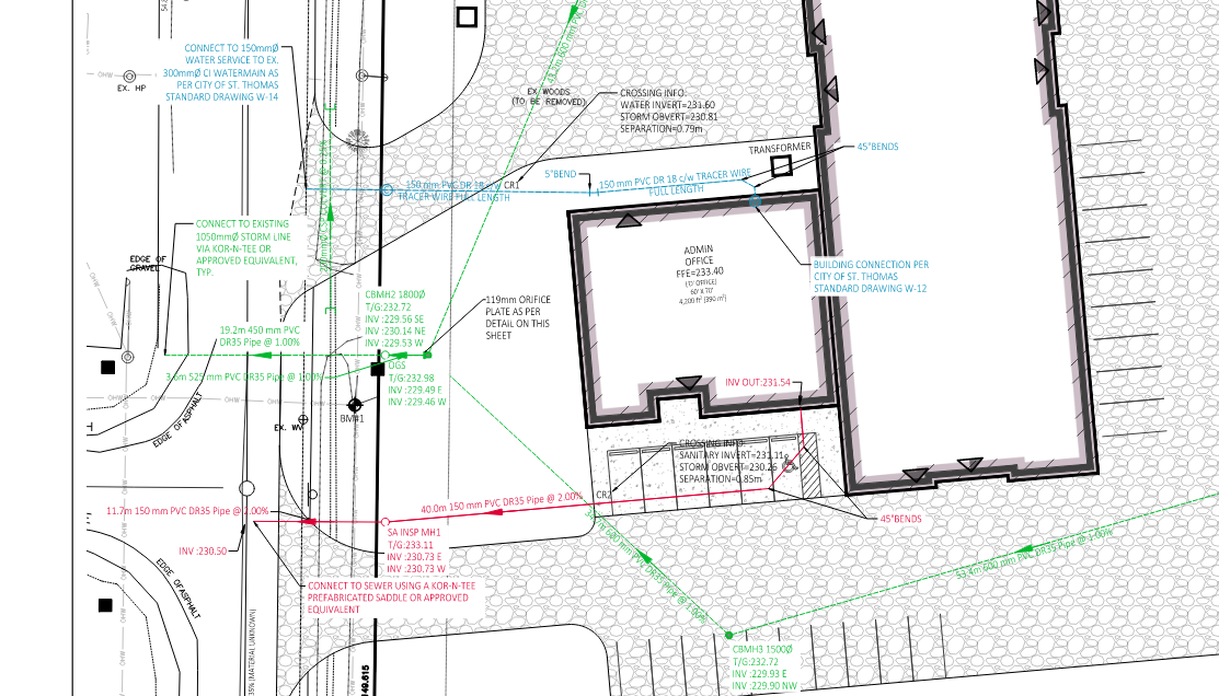
Example of design of storm (green), sanitary (red), and drinking water (blue), services connecting to building
In conclusion, grading is a critical part of infrastructure design, ensuring that stormwater is managed efficiently while maintaining the integrity and aesthetics of the site. By leveraging advanced tools like Civil 3D and collaborating with other design disciplines through platforms like Autodesk Suite, co-elevate creates precise, reliable, and visually rich designs. These detailed models not only streamline the construction process but also provide clients with clear insights into the project's scope and functionality. Our commitment to accuracy, efficiency, and collaboration ensures that every grading project is executed to the highest standards, from concept to completion.